
History of Cawfields Wall, Milecastle and Turret
The best-preserved sections of Hadrian’s Wall are within its central sector, where it crosses high uplands along the edge of a dramatic rock outcrop, the Great Whin Sill. One section traverses Cawfields Crags, where the Wall has been conserved over a distance of about three-quarters of a mile. At its western end, at Hole Gap near the abandoned Cawfields Quarry, lie the impressive remains of milecastle 42, and at the eastern end are the foundations of turret 41a, close to a deep pass through the Great Whin Sill at Caw Gap.
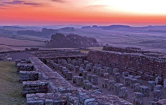
Hadrian’s Wall at Cawfields
Hadrian’s Wall on Cawfields Crags includes a short section at the wonderfully named Thorny Doors, where it survives on a steep slope, up to 14 courses or 3 metres high. This is one of the tallest surviving sections along the Wall’s entire length.
At the eastern end of the crags, the Wall descends a moderate slope to Caw Gap, where a modern road crosses its line. Here the Roman builders cut a deep ditch (which is still visible) on the north side, alongside and parallel to the Wall, to give it greater protection.
On the higher ground on Cawfields Crags, where the northward slope is steep, such extra protection was unnecessary. However, another short section of ditch appears at the western end of Cawfields Crags, near milecastle 42, where the Wall once again descends to lower ground at Hole Gap.
The tumbled remains of Hadrian’s Wall on Cawfields Crags were taken into state guardianship in 1960 following a long campaign to protect them (and other sections). For many years previously, the remains had been threatened or damaged by quarrying, and a large stretch of the Wall was destroyed by the working of Cawfields Quarry from 1902. Once protected, the remains at Cawfields were exposed and conserved between 1960 and 1973.
Centurial stones
Several ‘centurial stones’ have been found in the area, inscribed with the names of the Roman military units and their commanding officers who built or repaired sections of the Wall. One of these was inscribed ‘the century of Gellius Philippus [built this]’ – a century being a unit of 80 men.
Another example is particularly interesting because it records building work by civilians of the Durotriges tribe, who came from ‘Lindinis’ – probably Ilchester in Somerset. A second stone with a similar inscription was found somewhere to the east, towards Housesteads Fort, and four or five more are known from other Wall locations. These record three other tribes – the Dumnonii (from modern Cornwall and Devon), the Catuvellauni (from modern Bedfordshire, Buckinghamshire, Hertfordshire, south Cambridgeshire, east Oxfordshire and the west Essex area), and the Brigantes (from northern England).
Clearly, civilians who lived a long way from the Wall helped to repair it at some time in its history, but under what circumstances – paid or enforced – is unknown.
Milecastles on Hadrian’s Wall
Milecastles were part of the original design for Hadrian’s Wall before a major change of plan – to incorporate large forts on the Wall – was made part way through its construction.
In the original design, each milecastle protected a gateway through the Wall. We don’t know whether they were designed to allow soldiers to pass through and patrol to the north, or to check civilian movements in and out of the province, or perhaps both. Each milecastle probably had a small garrison of around eight soldiers living in a single barrack building, though some had two buildings capable of accommodating more, perhaps up to 32 soldiers. These larger garrisons may have manned milecastles in more vulnerable locations.
Milecastles were small rectangular defended enclosures, with walls between 15 and 18 metres along one internal side and 17–23 metres on the other. Some have their longer axis parallel to Hadrian’s Wall (short axis type) while others have it perpendicular (long axis type). Variation in detail includes the form of the gateways and the number and type of internal buildings. There were usually gates in both the north and south walls, the former probably surmounted by towers. There may also have been buildings outside the walls, although this has not been widely studied.
The term ‘milecastle’ was first used in the early 18th century. In the late 19th century, the milecastles were numbered from 1 to 80, beginning at Wallsend at the eastern end of Hadrian’s Wall. Many have been excavated but only six have substantial visible remains. English Heritage cares for four of these: Sewingshields (35), Cawfields (42), Poltross Burn (48) and Harrows Scar (49), plus one other at Grindon (34), where there are no remains above ground.
Cawfields Milecastle (42)
Cawfields milecastle occupies steeply sloping ground at a strategic position overlooking Hole Gap, where Hadrian’s Wall descends to cross a small area of lower, flat ground before climbing again. This was a potential weak spot where intruders might pass over the Wall unseen.
The site was excavated in 1847–8 and 1936, but no trace of internal buildings remained and there seem to have been few finds. In places there is no soil, only exposed bedrock, so it is likely that most archaeological evidence for the internal structures is now lost.
However, the milecastle’s defensive wall is in reasonable condition, and the two gateways are particularly fine. These are built of monumental stone blocks that would have carried substantial arched gateways; the northern one was probably surmounted by a tower. At the outer ends of the gate passages, circular sockets in the stonework on each side show the positions of iron pivots for the double inward-opening gates.
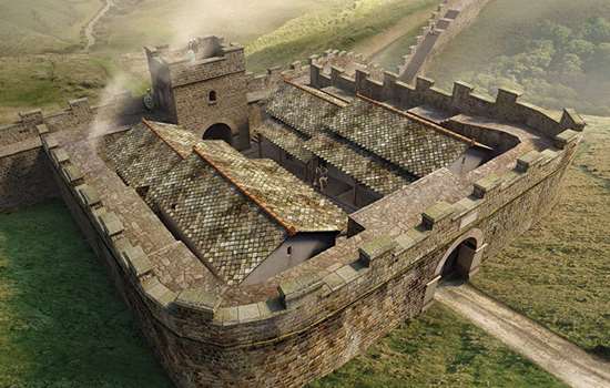
An artist’s reconstruction of how Cawfields milecastle may have looked in about AD 130, when newly built
© Historic England/English Heritage Trust (illustration by Mikko Kriek)
Inscriptions from the milecastle
Two important inscribed stones were found in the milecastle during excavations in 1847–8. One was part of a stone slab, which would have been positioned above one of the gateways. It was dedicated to the emperor Hadrian and commemorated the building of the milecastle by men of the Second Legion Augusta, during the period when Aulus Platorius Nepos was governor of Britain (AD 122 to c.AD 126).
The second stone had been shaped and reused, possibly as a hearth stone, but enough of its inscription survives to reveal that it was originally a tombstone. It had been set up by a woman called Pusinna, the widow of Dagvalda, a soldier who served in the 1st Cohort of Pannonians, possibly at the end of the 2nd century AD. The Pannonian unit was originally raised in a Roman province far away, south of the river Danube in eastern Europe.
The turrets of Hadrian’s Wall
In the original design for Hadrian’s Wall, about 160 turrets were built along it, two to every Roman mile. They provided lookout positions for small groups of soldiers to monitor people’s movements north of the Wall, and shelter and basic facilities for the men on duty. Two turrets were positioned between each pair of milecastles, which probably provided the troops for duty at the turrets.
Sometime after work on the Wall began, and well before its completion, a decision was taken to build large forts such as Chesters and Housesteads to hold garrisons of 500 and sometimes 1,000 soldiers. By this time many turrets had been begun or completed, and some were demolished to make way for the forts.
Each turret was about 6 metres square externally, its interior space recessed into the thickness of the Wall and entered through a door in the south wall. Turrets were probably two or three storeys high, but their full height and design above the ground floor is uncertain. They may have had open observation platforms with parapets, or pitched roofs covered with tiles, thatch or shingles. The evidence differs from one turret to another, and roof construction may have varied over time and by location.
Excavations at many turrets have produced evidence of how soldiers used them. Pottery, cooking utensils and items such as gaming counters show that small groups of soldiers routinely cooked, ate, relaxed and probably slept in turrets during their periods of duty on the Wall.
Turrets are numbered in relation to milecastles: each pair takes the number of the nearest milecastle to the east, ‘a’ for the eastern turret and ‘b’ for the western one.
Caw Gap Turret (41a)
Hadrian’s Wall and turret 41a, looking east towards Caw Gap. The stub of a wing wall can be seen in the centre foreground, showing that construction of the turret was at least begun with a short section of the intended broader width of the Wall, before the main body of the Wall was built up to it at a reduced width
© Andrew P Walmsley/Alamy Stock Photo
Turret 41a sits close to a pass through the Great Whin Sill at Caw Gap. A road runs through the gap today, and it must always have been a way through the rocky outcrop. The turret lies at the eastern end of Cawfields Crags, close to but not directly overlooking the gap.
Only the foundations of the turret survive because it was demolished in Roman times and the Wall rebuilt over it. This was part of extensive alterations along the frontier that accompanied military campaigns north of Hadrian’s Wall by the emperor Septimius Severus in AD 208–11. The position of the blocked doorway into the turret, in the south wall, is apparent, as is the straight face of the turret’s internal north wall, which was not quite concealed by the stonework of Hadrian’s Wall as rebuilt over the northern quarter of the demolished turret.
Like some other turrets on Hadrian’s Wall, turret 41a was built with short ‘wing walls’ to either side, which are just under 10 Roman feet (3 metres) wide, the original intended thickness of the Wall. By the time the main body of the Wall was built to join the turret, it was being made narrower, so the facing stones of the wing walls on the south of the Wall can still be seen.
By Paul Pattison
The Wall nearby
The walk eastwards from a car park at Cawfields Quarry passes Hole Gap and climbs over Cawfields Crags and Thorny Doors to Caw Gap. It is a fine stroll alongside Hadrian’s Wall, no more than a mile, with panoramic views.
A longer walk of 3 miles westwards from the car park takes you to Walltown Crags, where there is another spectacular section of Hadrian’s Wall, including two more turrets, nos 44b and 45a.
Find out more
-

Emperor Hadrian
Learn about the man behind Hadrian’s Wall, the most impressive statement of his policy of securing the empire’s existing borders.
-
EXPLORE ROMAN BRITAIN
Browse our articles on the Romans to discover the impact and legacy of the Roman era on Britain’s landscape, buildings, life and culture.
-
Hadrian’s Wall: History and Stories
Discover the history and stories associated with Hadrian’s Wall, the north-western frontier of the Roman Empire.
-
MORE HISTORIES
Delve into our history pages to discover more about our sites, how they have changed over time, and who made them what they are today.